Background on McCullough Peaks
McCullough Peaks is a Wilderness Surveillance Area in between Cody and Powell, though it is closer to Cody. The Peaks are badlands. The word “badlands” has an interesting backstory! The name comes from the indigenous Lakota people who originally described the Badlands National Park in South Dakota as “mako sika“. This directly translates to “bad lands”. The reasoning is because the area is rocky, lacking water, and has extreme temperatures.
Today, there are a number of ways that people enjoy their time in McCullough Peaks. No matter what you like, something fun can be done at one of The Peaks’ many off-road trails and paths. People are known to ride off-road vehicles, go horseback riding, mountain bike, hunt on a limited basis, camp, and hike.
People also hunt for fossils here! McCullough Peaks is rich with fossils. Millions of years ago, The Peaks were warm and swampy. Fossils of old crocodiles, lemurs, and other mammals from that time have been known to be hiding around the area!
If you would like to learn more about the history of The Peaks, here is a great article from a PEP contributor that dives deeper!
Wild Horses in The Peaks
McCullough Peaks has large expanses of open plains-like land. One of the major draws to this area is the chance to see a herd of wild horses (which I unfortunately did not)! The wild horse herd management area protects this herd. Rumor has it that this particular herd are descended from the horses used in Buffalo Bill’s Wild West Show! There is a guide service in Cody that leads groups on wildlife spotting tours in The Peaks. That information can be found here.
The Cody based non-profit Friends of a Legacy (FOAL) is dedicated to keeping the horses of McCullough Peaks “wild” and “free”. Operating since 2006, this organization has been working hand in hand with the BLM. To support their efforts please consider donating so that this local attraction can continue to thrive.
The Hike
I had to phone a friend for the hike I’m about to describe! A buddy and I hiked/scrambled our way through the McCullough Peaks Divide Trail. He had been to the area a few times before and knew of some of the more popular trails. To be clear, this hike took place on a different visit to The Peaks.
This hike is an out and back trail that is about 6 miles round trip. It took my friend and I ~three hours to complete. If you are up for a physical challenge, this hike is for you! There is a fair amount of scrambling we did that was tough on my bad knee (yes, people in their 20’s can have a bad knee).
Despite the physical pain I enjoyed clambering up and over the little rolling hills this hike took us on. It kept my mind engaged on what was right in front of me because I was so focused on not falling and listening for rattlesnakes. I like situations like this where you can just turn your brain off and be totally in the moment.
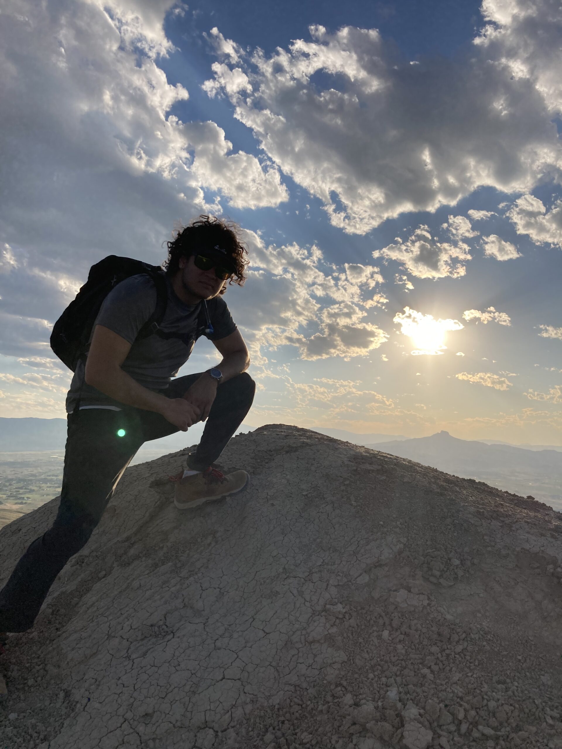
It was tremendously satisfying to get to the summit and be rewarded with great views and the right to sign our names in the logbook stashed up there. It was cool to read through all of the names on the list and see the little notes they left behind!
The state of the trail made this hike confusing. In multiple sections the trail would disappear or branch off in several ways. We would go one way and then see the trail off to the side of us. Following the trail was unclear for most of this hike.
Eventually we gave up on trying to stay on the path. We figured out where the summit was and headed straight for it.
New Territory for Me!
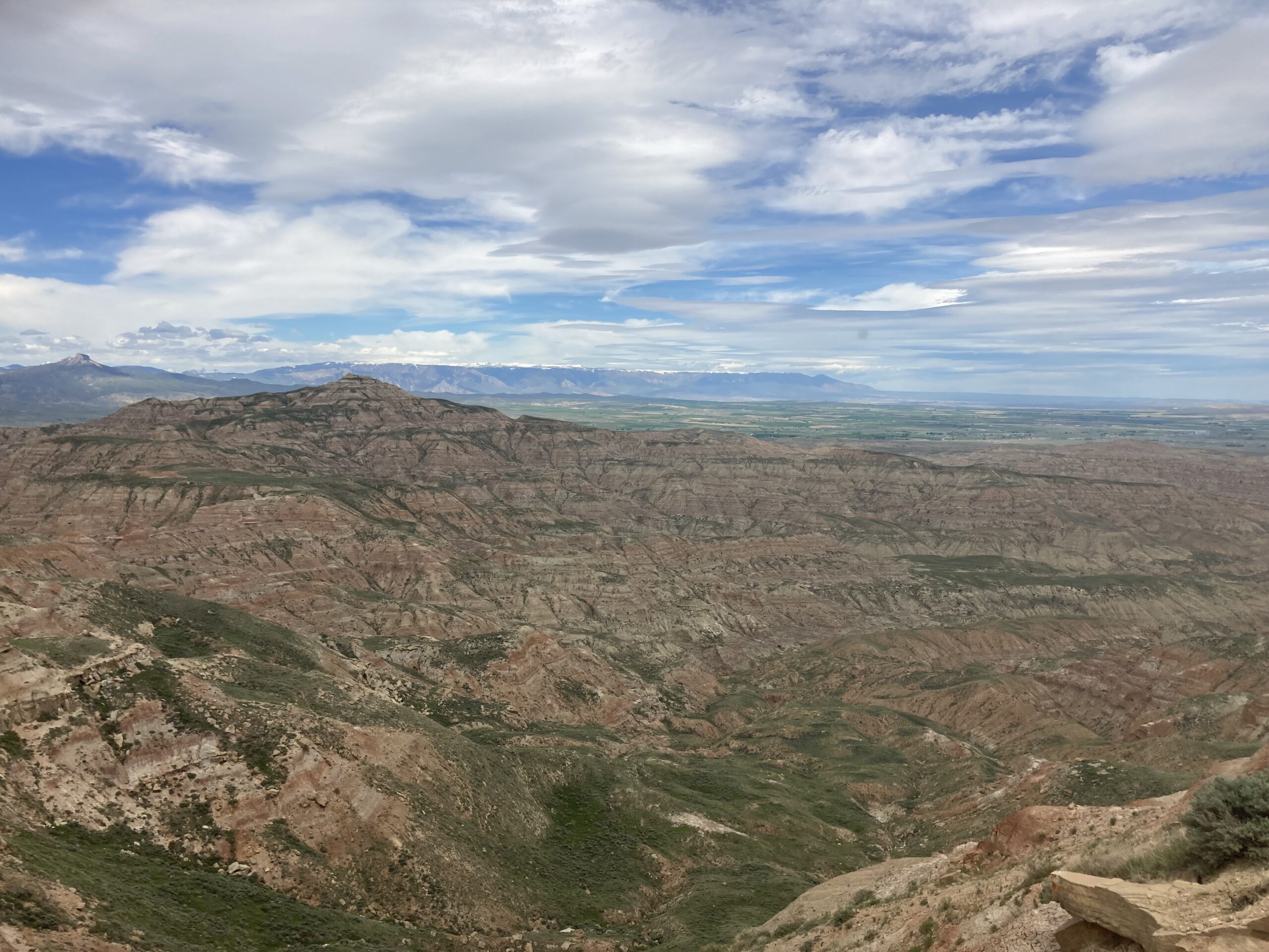
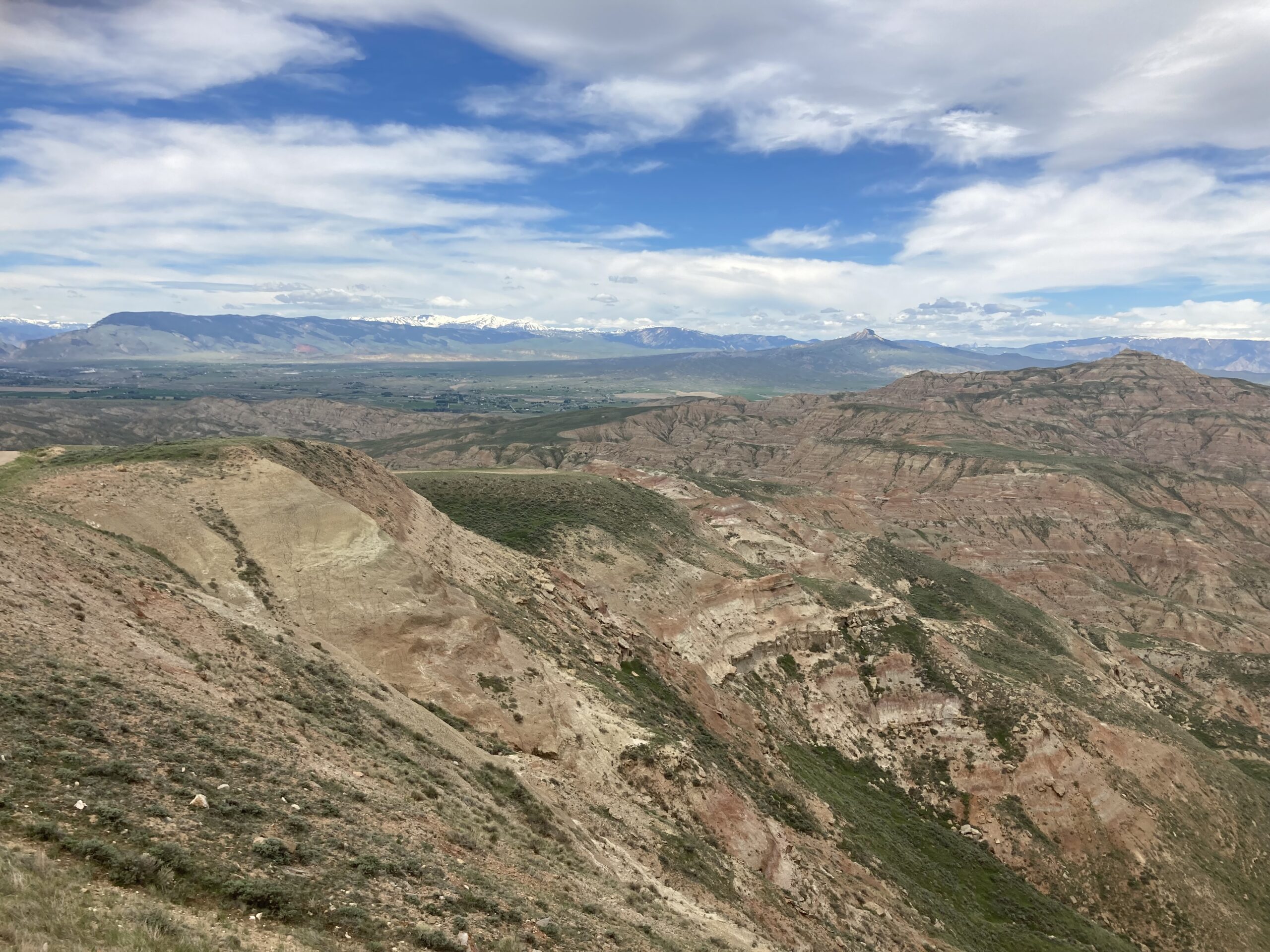
I had never seen anything in my life that looks like McCullough Peaks before I moved to the American West. The North East is covered in trees and littered with streams and little ponds/lakes. Then of course we have the Atlantic ocean right next door. The Peaks were so strange to me because I had never seen badlands before. The lack of trees was a shock!
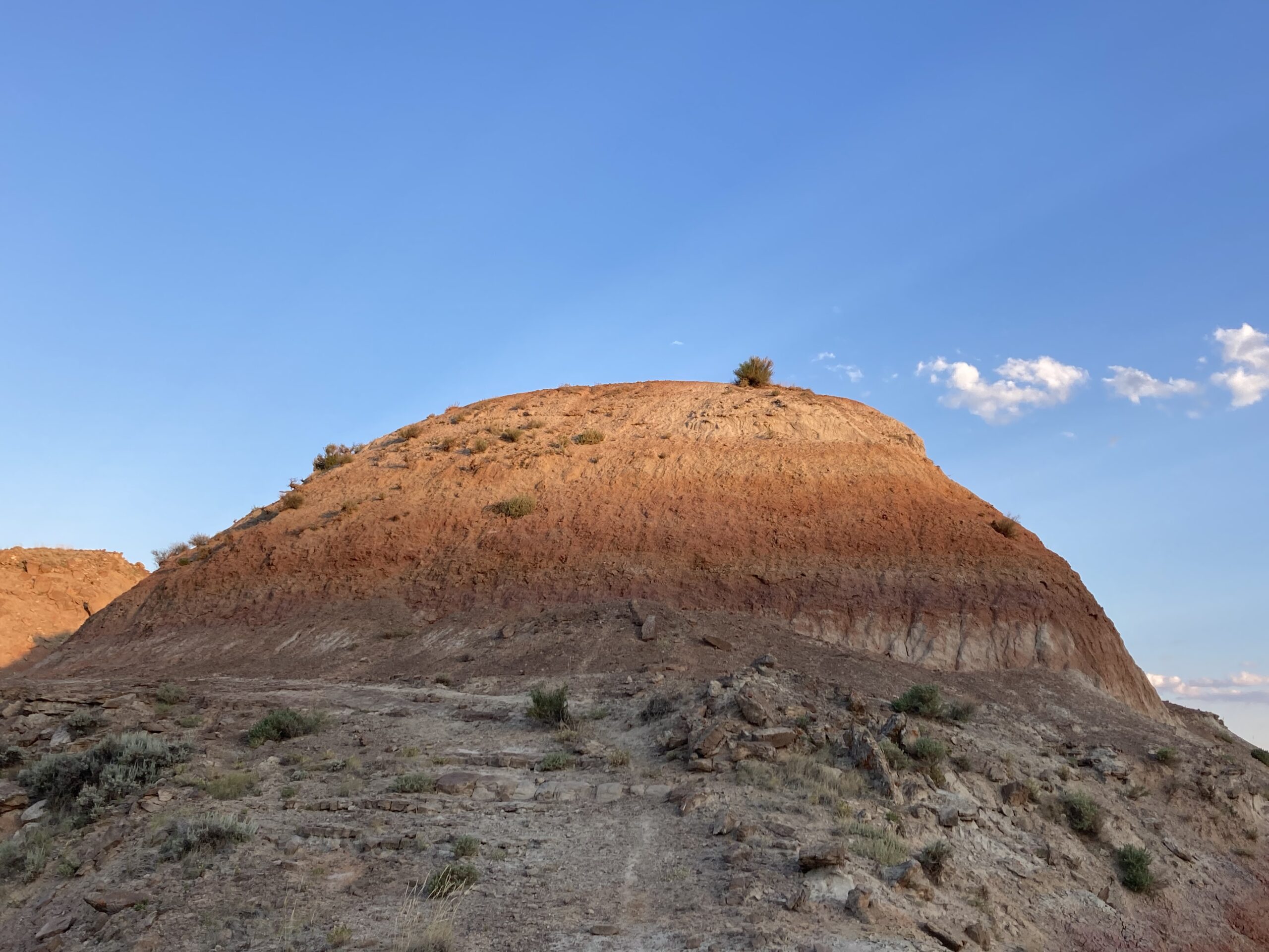
Nothing does not mean boring or uninteresting, the views from McCullough Peaks are stunning. You have sightlines for what seem like 100s of miles. Nearby mountain ranges and prominent features of the landscape reveal themselves as you climb higher.
McCullough Peaks is the second hike I completed after arriving to Park County for my VISTA service. It was amazing being so high up because being from Boston we are obviously at sea level! It feels like no matter where you are in Park County you are at least 5,000 feet above that.
Something I’m a little embarrassed to share with you is that during my interview for this job I bragged about climbing a mountain that topped out at 5,000 feet! To those curious I’m talking about Mt. Lafayette in the White Mountains up in New Hampshire. Before I looked at maps of Park County I thought this was a massive mountain. I thought this would make me seem ready for anything I would have to tackle out here. Come to find out, the shortest mountain in Park County has that beat by 1000’s of feet!
An Interesting Conversation
As I was scaling the sides of McCullough Peaks in my Honda Accord I came across two tourists from the Greater Boston area! This is where I’m from in case you haven’t read my first blog post (check it out!). They were on the road to Yellowstone.
I’m devoting a small section here to what we talked about because I think it is relevant to the entire reason I am writing this blog.
The herd of wild horses drew them to the area. When I asked, they said they were not aware of any other place to see in Park County other than Yellowstone and The Peaks. So from a tourist standpoint, wild horses seems to be of significant interest.
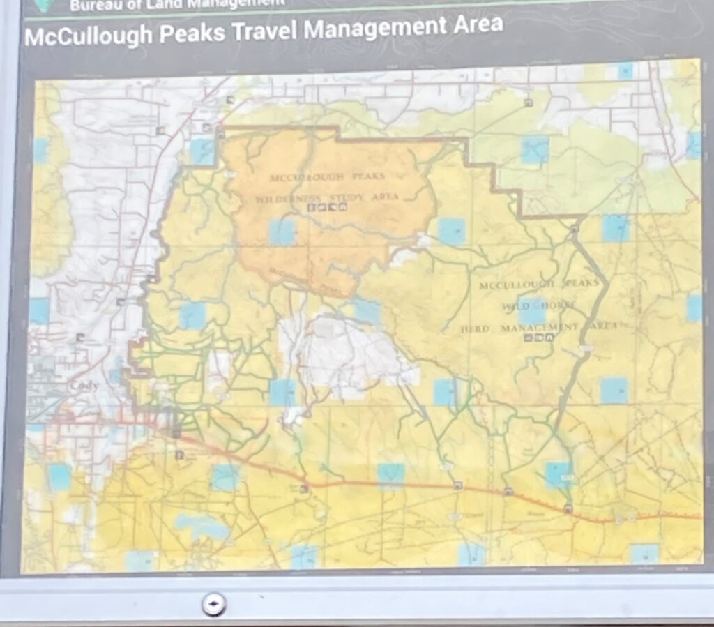
The couple shared a lot of the confusion I had about signage at McCullough Peaks. They noticed the map at one of the access points but they were unsure of how long the road was or where any points of interest were. Park County is difficult to navigate for newcomers because they do not think to download any maps as they will not expect to lose cell service.
However, they shared similar concerns that locals may have about promoting the area. They were concerned about the area flooding with people. So any changes to infrastructure should be minimal to avoid overcrowding in their opinion.
Access
Positives
The Bureau of Land Management (BLM) almost entirely manages McCullough Peaks. There is also some private and state owned land. There are no fees at any of the entry points of The Peaks. If you like, you can camp at no cost for a maximum of 14 days. They can kick you out if they find you I guess!
One great positive about McCullough Peaks is that it is so close to Powell and Cody. I would say this is a place you can go to spend most of the day, an afternoon, or just a couple of hours given how close it is! The entry points are clear and distinct, all having a map of the area provided by the BLM and various notices posted on kiosks.
Negatives
While the map is helpful, it is too large and cannot show with detail all of the branching paths off of the main road. How about a “You are here”? I had never been to McCullough Peaks before and I was very new to the area at the time so I really wasn’t sure where I was on the map.
Picking a hiking trail was confusing. The lengths of the designated hiking trails are unmarked which was slightly intimidating. Like when I went to Polecat Bench, I simply googled “McCullough Peaks” on Maps and it did not show me any of the popular trails. This made it confusing because I was not sure which hike I should’ve done. I drove to the point google picked out but there were no trails at that spot. Eventually I made my way through the entire area without ever figuring out where the popular hikes are. This is why I had to come back with a friend.
It is worth mentioning that there are no restrooms, trash cans, or clear places to park at McCullough Peaks. While parking is not clear there is plenty of space to do so.
Lastly, access is far easier with a 4WD vehicle with a lot of clearance or an ORV. I was lucky because I went on a dry day, if it had rained the road would have been impossible for me.
Rating 3/5
The best part about McCullough Peaks is that if you were to camp there for the full 14 days, you’d have something new to do every day. There are a variety of ways to enjoy what McCullough Peaks has to offer. While driving on the main road I saw people riding dirt bikes/ORVs, hiking, looking for wildlife, and searching for fossils. Out of all the places I’ve been so far, I saw the most people here.
The views from The Peaks are incredible, even though the summit does not even come close to the height of Park County’s mountains. It almost feels as if you are walking on the surface of a different planet at times once you get a clear view of the immediate and surrounding landscape.
Based on what I just said you’re probably wondering why I’m giving McCullough Peaks a 3/5. The confusing aspects are really holding this one back from being a 4 or even a 5 on a good day.
The first time I came to The Peaks I didn’t even get out of my car to hike as I said earlier. I didn’t know how long the trails were or where the popular hiking spots were either. Signage and trail maintenance needs to improve here for this score to go up.
What You Need to Know
- Here is a link to the most popular hikes at McCullough Peaks!
- Its doable without, but I recommend a vehicle with high clearance and 4WD
- Download your map!
- Be wary of rattle snakes. Here is some information about rattlesnake safety.
- Be aware that there are no restrooms at McCullough Peaks.
What’s Next?
I’m hoping to post every other Monday starting on October 17th.
Get ready to read about my first time hiking up Heart Mountain! You can read more from me and other contributors to PEP here.
- Visitor Guide to Bridal Veil Falls (Clark Fork’s Canyon) - February 22, 2023
- Visitor Guide to Heart Mountain - October 24, 2022
- McCullough Peaks Review - October 10, 2022
